Last Post on
The Apricot Road to Yarkand -
Book is available at Sang e Meel (042-3722-0100), Lahore
Labels: Books, Photo Stream, The Apricot Road to Yarkand
posted by Salman Rashid @ 00:00,
,

Excerpt:
Journey’s End,
Review by Maheen Pracha
Book is available at Sang e Meel (042-3722-0100), Lahore
Labels: Photo Stream, The Apricot Road to Yarkand, Travel Photography
posted by Salman Rashid @ 00:00,
,
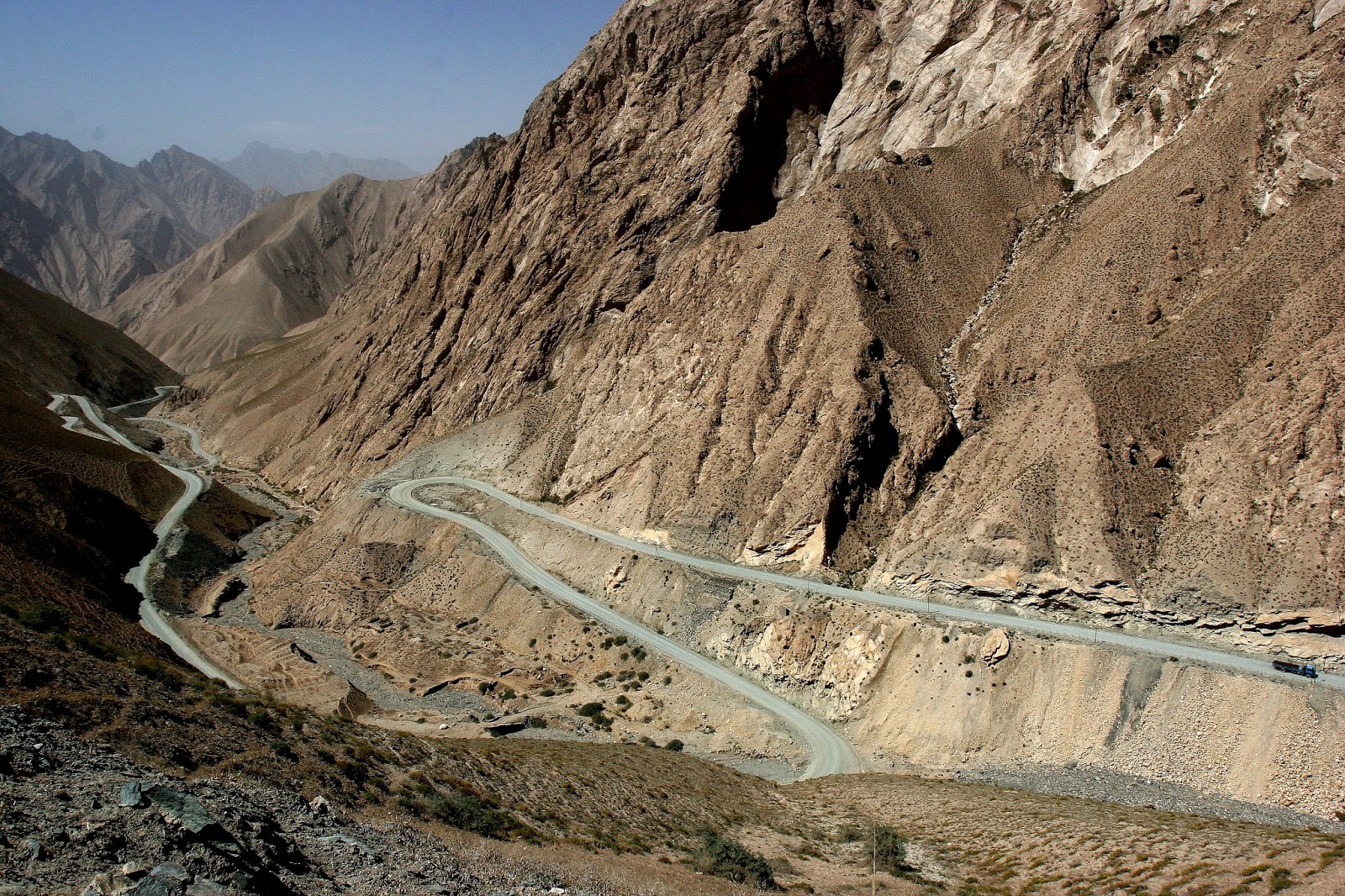
I called the bends in the Kuday Dawan jalebi from the name of a stretch of road in Zanskar (near Kargil in India of which I have seen some images). These bends in the Kuday have no similarity with our
Khyber Pass. For one, the scale is much grander in Kuday at 3300 metres as against the 600 metres of our Khyber. Secondly, I have seen fewer places as dreadfully desiccated as the Kun Lun Mountains; the Suleman Mountains would be a virtual oasis in comparison. Also there are villages in the Khyber, boys grazing livestock, traffic driving past etc. The Kuday is utterly, utterly uninhabited.
From The Apricot Road to Yarkand -
Book is available at Sang e Meel (042-3722-0100), LahoreLabels: Photo Stream, The Apricot Road to Yarkand, Travel Photography
posted by Salman Rashid @ 00:00,
,
Book is available at Sang e Meel (042-3722-0100), Lahore
Labels: Books, Photo Stream, The Apricot Road to Yarkand, Travel Photography
posted by Salman Rashid @ 00:00,
,
Shaksgam River valley - the view is to the east in the direction of the
Shaksgam headwaters
[Image from
The Apricot Road to Yarkand - Book is available at Sang e Meel (042-3722-0100), Lahore]
Labels: Books, Photo Stream, The Apricot Road to Yarkand, Travel Photography
posted by Salman Rashid @ 00:00,
,
On the left, Chhogho Ri (K-2) the Great Mountain of the Baltis (that is what the name means), Chogar of the Uighur and Kirghiz people of Xinjiang and Chogoli of Chinese. At a little before eleven when I became the first Pakistani to see its north face, the mountain was blue clad. This image was only for the record.
Labels: Gilgit–Baltistan, Photo Stream, The Apricot Road to Yarkand, Travel Photography
posted by Salman Rashid @ 00:00,
,
If there was ever a lonely place I had been to, it was the country on the south side of the Aghil Pass. The Shaksgam Valley here is as desolate as it can ever get. Our caravan is approaching the Kindik Tash camp ground.
Labels: Books, Photo Stream, The Apricot Road to Yarkand, Travel Photography
posted by Salman Rashid @ 00:00,
,
Hassan Karrar, is thin as a rail, stands six and a half feet tall and teaches history at LUMS. He walks with a long step and is known in Baltistan as ‘lumbi tango walla’ – long-legged man. At Pakistan International Mountain Film Festival he and I talked of the philosophy of mountaineering and the question of ‘conquering’ peaks.
First things first. No one conquers peaks. We conquer enemies; not peaks. The only thing anyone has ever conquered attempting a summit is their own fears. That’s all.
Read more »Labels: About, Between Two Burrs on the Map Travels in Northern Pakistan, Books, Guest Speaker, Mountaineering, Mountains, Salman Rashid, Salt Range, The Apricot Road to Yarkand
posted by Salman Rashid @ 00:00,
,
Book is available at Sang e Meel (042-3722-0100), Lahore
I was fortunate to get the plane from
Kashgar to Islamabad and thus escape the bone-jarring 16 hour bus ride from the former to Gilgit where I would have laid up for the night and then faced another similar journey of equal duration to Rawalpindi. And then another few hours by train or coach to
Lahore. But from the beginning.
We were equally lucky going out for we got the plane to Skardu on 10 August where we found everything in order waiting for us. Ghulam Mohammed, who was handling this trip, is a very good operator. On the following morning we were on the jeeps to
Askole - World's End. I bore with me a framed photograph of Haji Mehdi who ran that store in Askole back in 1990 where we purchased, among other things a bag of potato mix which was mistaken for powder milk up on Lukpe La and we had potato tea - a novelty, but who had since died. His sons now run a little inn in the village. So now I have a photograph of one of his sons holding up a picture of their father. The walk began the next morning and we went up the Panmah Glacier. On the fourth day out we reached Shingchakpi Camp Ground where Godwin-Austen had met with the four Baltis coming out of the swirling storm clouds. Weather remained persistently bad with clouds obscuring the higher peaks and daily evening showers of rain.
Labels: Books, Muztagh Pass Expedition, The Apricot Road to Yarkand
posted by Salman Rashid @ 00:00,
,
For the first time in our days in the mountains, the morning dawned clear and bright without a speck of cloud in the sky. However, shortly after sunrise, a blue skein was perceptible all around. There was no breeze but it was bitterly cold despite the fact that our height, since descending into the
Shaksgam, had remained uniform at about 3900 metres. Without the usual gusting wind, taking down and packing the tents was still an ordeal because their surfaces were crinkly with rime.
 |
| Chhogho Ri, the Great Mountain of the Baltis and
the Chogor of the Uighur and Kirghiz people of Xinjiang. At a little before
eleven in the morning when I became the first Pakistani to see its north face,
the mountain was blue-clad. This image was only for the record |
Immediately after striking camp, we rode the camels thrice in quick succession to cross narrow channels each nearly a metre and a half deep. About us shingle slopes altered with river terraces their verges sliced as if by the surgeon’s knife or grey-brown slopes of stark rock. In front, Kindik Tash seemed to recede as we approached it. Telling us to keep to the rocky slope along the left bank, Seet now rode his lead camel and was continually crossing and re-crossing clear blue channels.
Read more »Labels: Books, China, Muztagh Pass Expedition, The Apricot Road to Yarkand
posted by Salman Rashid @ 00:00,
,
 |
River terraces sliced as if by the surgeon’s
knife was a description first given by Eric Shipton during his 1937 Shaksgam
Expedition. It is still true. Because of negligible precipitation, there is
little erosion and the verges of the Shaksgam Gorge keep their shape
|
Francis Younghusband’s account elides rather hurriedly over the journey from where he left the Yarkand River valley in the Raskam neighbourhood, to traverse the length of the Surukwat, over the Aghil and into the Shaksgam valley. Strangely, he assigns no name to the pass; his description is exact nevertheless:
The height was beginning to tell, and the pass seemed to recede the nearer I approached it. One rise after another I surmounted, thinking it would prove the summit, but there was always another beyond. The valley was wide and open, and the going perfectly easy, leading sometimes over rounded boulders, but more often loose soil.
With Wahab and Seet slowly bringing up the camels, I hurried on across the stony ground of Chonkor Utik to the chevron of converging ridges just below the great slanting wall of snow to the left. The pass itself was three false crests and two and a quarter hours from our camp. The Surukwat, never a mighty river in its short life to its junction with the Yarkand near Ilica, was but a piddling spill here. It got ever sparser as I neared the pass.
Read more »Labels: Books, China, Muztagh Pass Expedition, The Apricot Road to Yarkand
posted by Salman Rashid @ 00:00,
,
Leaving Karghalik after four in the afternoon we entered a boring landscape shrouded in a pall of dust that settled thick on one’s person. So pervasive it was that its heaviness choked the nose. An hour out, we passed Kokyar – Blue Earth. But for the two remarkable circular sand dunes that looked like huge mounds of grey pudding sitting to the east side of the road, it was scarcely a noteworthy village. Nothing was even vaguely blue about Kokyar, not even the sky.
 |
| The jalebi bends in the Kuday Dawan. This
area is utterly desiccated because of little rain |
One hundred and fourteen kilometres from Karghalik we were in the heart of a pass that Wahab said was the Kuday Dawan after a village of the same name on its south side.* In the failing light, we saw below us a series of hairpin bends that may have looked pretty were they not muffled by the thick haze of dust. But here in the dusty landscape utterly without tree cover, they could best be described as bleak. They reminded me of pictures I had seen of the Jalebi Bends of Zanskar in Indian Kashmir – only; the latter place was somewhat the greener.
Read more »Labels: Books, China, Muztagh Pass Expedition, The Apricot Road to Yarkand
posted by Salman Rashid @ 00:00,
,
Ever since I first heard the name back in the mid 1980s, I was mystified by it: why should Kashgar, a few thousand kilometres from the nearest ocean, have a hotel called Seamen’s? It was actually Seman (with a nasal ending) which ended up wrongly spelled in some shoddy guide book and thus passed into tourists’ usage. There are actually two of the same name, both multi-storeyed, facing each other across a wide street. Taking a room in the older one which has the old Russian Consulate in its backyard, I called Keyoum Mohammad of Kashgar Mountaineering Adventures with whom I had corresponded from Lahore.
 |
The old quarter of Kashgar as seen from the
north. Strangely, pictures dating back to the 1880s do not show a town on a
high mound, but one flush with the flat ground. The Chinese government is
encouraging Uighur people who live in this part of town to abandon it and move
to modern apartment blocks in the newer areas of Kashgar. Sooner than later,
the old town will be abandoned and razed to the ground
|
Completely bald, round-faced and chubby Keyoum brought along a young man with a jutting jaw and eyes that crinkled into slits when he smiled. My trekking permit, said Keyoum, was expected any day now. But I had telephoned him from Skardu three weeks earlier to tell him when I would reach Kashgar. Wasn’t that time enough for the permit to be organised? Permits normally took only a couple of days to be processed, he said, and though delays were not unknown, there was no reason to worry if mine had still not come through. Keyoum said he had brought along young Wahab, my interpreter and guide, so that we could get to know each other. Beginning the next morning, Wahab was to gainfully employ the waiting time showing me the sights of Kashgar.
Read more »Labels: Books, China, Muztagh Pass Expedition, The Apricot Road to Yarkand
posted by Salman Rashid @ 00:00,
,
Abort!
27 January 2014
Abort!
Sometime in the latter years of the 18th century the Old or East Muztagh Pass became difficult, ‘because of an excess of snow and ice’ – or so it was believed – and fell out of use. There seems to have been an almost desperate need to maintain the direct connection with Turkistan because when Raja Ahmed Shah ascended to the throne of Skardu in the year 1800, he forthwith ordered reconnaissance for an alternate route.
 |
Heading out for the West Muztagh Pass. Hasan Jan
(second right) carries the mountaineering gear in his backpack in the vain hope
of taking us across the Great Asiatic Watershed
|
Armed with nothing more than a keen sense of topography and perhaps hand-drawn sketch maps, the work of hunters and shepherds who frequented the mountains, teams of explorers set out to find another route across the
Great Asiatic Divide. Today there is no historical evidence of the existence of Balti maps, nor does folklore refer to them, but it is not hard to imagine that before setting out the explorers consulted with those who had gone before. The lay of the mountains would have been explained in great detail, the flow of the rivers for the particular season, camp sites with good fuel and water and those, like Shingchakpi, to be avoided and where game to sustain the survey team was to be found were all enumerated together with travel time from Askole.
Read more »Labels: Books, Muztagh Pass Expedition, The Apricot Road to Yarkand
posted by Salman Rashid @ 00:00,
,
The day dawned miserable and grey – the daily pattern thus far – as we prepared to leave Ghwang Lungma. A thin but steady drizzle set up when we entered the moraine and struck out northeast across the broken glacier. For forty-five rather difficult minutes I skidded and tumbled on the scree-covered ice marvelling how the others kept their footing. Crossing the glacier diagonally, we would have remained on it for a length of only about three kilometres, yet it took us about two hours to attain the left bank of the Panmah. Thence the going was easy along the moraine.
 |
Shingchakpi camp ground whose name signifies a
total absence of fuel wood. It has a number of bitter streams flowing down from
the south across the sand pan which is always damp and would make one lousy
camping place. Henry Haversham Godwin-Austen camped here in August 1861 and was
surprised by four Balti travellers returning home from Yarkand
|
Three hours out of camp we were in the sandy pan of Shingchakpi Braungsa jammed between a dark crag to the south and the jumbled up moraine of the Chiring Glacier to the north. Braungsa (with a nasal ng) is camp ground in Balti while shing is timber. The name signifies a camp ground to which, should you plan to spend a night there, you take your own supply of firewood. At 4100 metres above the sea, this camp ground is no higher than, say, the Deosai Plateau south of Skardu where abundantly growing Salix bushes provide fuel. But true to its name, Shingchakpi only had some wild flowers and grasses.
Labels: Books, Muztagh Pass Expedition, The Apricot Road to Yarkand
posted by Salman Rashid @ 00:00,
,
Past the straggle of houses, the path was shaded by willows and poplars and I paused to look over the walled-in garden where I had spent a night back in July 1990. Nothing had changed in sixteen years. Then we were on the wide shelf spilling down from the bottom of the wall of granite on our left and disappearing into the gorge of the Braldu River on our right: we were stepping over the edge of the world. Across the Braldu, on its south bank, the village of Teste was visible together with neighbouring Korphe.
 |
| The right bank of the Panmah, along which we marched, was as series of scallop-shaped river terraces with gaps between. This entailed climbing to the top of one, traversing it and then descending again to the valley floor only to be confronted by the next. This terrace is called Biyarok Shi or Chough Dead |
Korphe is now well-known for the school built by an American mountaineer. Having failed on K-2 in the summer of 1993, the man was stumbling back to Askole when he failed to cross the river where he should have. Instead of making Askole he thus found himself dehydrated and dog-tired in Korphe. Nursed back to good form by the headman Haji Ali and his family, the American one day asked to see the local school. He found a bunch of children squatting in the open; the patch of ground immediately in front of each child serving as the copy book on which they did their sums and alphabets with styli of little pieces of wood. And so the American built the school, so said Salman, the porter who had fallen in with me as we left Askole.
Read more »Labels: Books, Muztagh Pass Expedition, The Apricot Road to Yarkand
posted by Salman Rashid @ 00:00,
,
On the ninth day of August 2006, the three of us met in Islamabad. Nasser leading the team, Naeem Awan, the man I had once taken for Japanese, was the doctor of the expedition and I, pretending to be the writer had upon us ‘the exploring spirit’. A century and a quarter before us the explorer Francis Younghusband wrote these words and ended up going mystic – although, it must be conceded, he did accomplish a few good things before descending into the search for the higher meaning of life and assorted silliness. We hoped to do somewhat better. At fifty-four years of age this was perhaps my last chance for such a caper. Nasser, some six years behind me, still had more seasons to look forward to while Naeem was in full form at thirty-two.
 |
| Downtown Skardu. Barely thirty years ago this
spot, lying about a kilometre east of the 1947 memorial, was about the end of town. Seen from the air, Skardu town of today sprawls in a hugely haphazard
line between the Sindhu River flowing to its north and the mountains to the
south |
Our expedition was being handled by Blue Sky Treks and Tours run by Ghulam Mohammed (GM). A native of Khaplu, the man, in his late thirties, had started out as a porter when still in his teens. He had worked hard, walked more times to Concordia at the foot of
K-2 than he cared to remember and a few times up and down the Biafo, knew virtually every rock in the eskers and moraines of the Baltoro and also some on the Biafo Glacier and was much smarter than he appeared at first sight. He spoke with a nasal twang – but Balti being a highly resonant language, most other Baltis did too – and went about his business of tour operator with what I perceived as feigned gravity.
Labels: Books, Muztagh Pass Expedition, The Apricot Road to Yarkand
posted by Salman Rashid @ 00:00,
,
The Rawalpindi-bound bus pulled up outside Satpara Inn in Skardu and honked for me. It had been arranged that the driver would pick me up at the hotel and he was only ten minutes behind his promised time. For me this had been a bit of a flop of an outing. Up on
Deosai Plateau, south of Skardu, I had only one good day. It was all right to expect a couple of bad days in the last week of July, but a full week of rain and then finally about three centimetres of snow was a bit too much. With no chance of the weather clearing, I had bolted. The two days in Skardu struggling to get on the plane out to Islamabad also did not work out and it was not with any enthusiasm that I looked forward to this overland journey.
I was packed and ready and as I lugged my rucksack to the vehicle, I noticed the good-looking face in the window: square with high cheek bones, rugged hollow cheeks and an indifferent moustache. He regarded me with just a shadow of a smile; I nodded and he nodded back. From his complexion and the auburn highlights in his hair I guessed he was a Spaniard. Probably a mountaineer who, like me, had either failed to get on the flight out of Skardu to Islamabad at short notice or whose flight had been cancelled because of the several days of horrid weather. As I brushed past him inside the bus I noted his somewhat large build and congratulated myself for my judgement being spot on from just a face in the window.
Read more »Labels: Books, Muztagh Pass Expedition, The Apricot Road to Yarkand
posted by Salman Rashid @ 00:00,
,
Back in Pakistan, I went to see Lieutenant General Zarrar Azim, who I had first met when he was the Lahore Corps Commander. An armoured corps officer with mischief in his eyes who still kept the verve of boyishness; he was the kind of person who would appreciate my endeavour. Since he knew and appreciated my work and was close to the president, he would gladly speak with the man, I thought. Having retired since our meeting in Lahore, he now headed Army Welfare Trust, an army-run commercial-industrial complex headquartered in Rawalpindi.
 |
The Panmah Glacier in its middle reach. In 1861 Godwin-Austen had reported an ice stream here; we found a roiling grey river. The scouring mark left by glacial ice on the rock wall along the left bank is a hundred metres deep. This was the depth at which the glacier once flowed here. If global warming is not halted now, another journeyer following in the footsteps of bygone travellers will probably find seasonal rivers where we had trodden on several hundred metre-deep ice
|
|
In his top floor office overlooking the Saddar Bazaar of Rawalpindi cantonment, I had his ear. But I did not even get a chance to ask the general for the helicopter. Having briefly told him of the journey I had barely finished my sentence about the missing thirty kilometres of the trek when he held up a hand.
Read more »Labels: Books, Muztagh Pass Expedition, The Apricot Road to Yarkand
posted by Salman Rashid @ 00:00,
,
Lukpe La (5700 metres) certainly was the highpoint of the 1990 expedtion described in
Between Two Burrs on the Map. It was actually quite a relief having made it that far and then across this icy pass. But there were many miles yet to go before I could end the expedition in Chitral and the feeling of actually having accomplished came on only after crossing Ishkoman Aghost (Pass) en route to Yasin that I got the first sense of nearing completion and success. The last thirty odd kilometers through the Golain Valley into Chitral were triumphant. I felt on the top of the world.

But in the 2006 expedtion (
The Apricot Road to Yarkand), there were at least three highpoints. First, the setting out from Raskam village where the jeep dropped my guide and me and we got the camels for the onward trek. Second, the attaining of Aghil Pass (4780 metres). This was because until 1963, this pass was part of Pakistan and had I been older, I could have been there without a passport. Also this was the source of the Surukhwat River that we had followed upstream since leaving Raskam. Third was entering the Shaksgam River valley at the bottom of Aghil because I had read again and again of it in Eric Shipton's classic of mountaineering and exploration Blank on the Map. No less exciting was becoming the only Pakistani to glimpse
the north face of K-2.
Read more »Labels: About, Between Two Burrs on the Map Travels in Northern Pakistan, Books, Northern Pakistan, The Apricot Road to Yarkand
posted by Salman Rashid @ 10:19,
,